
 Real estate CRM & 3D plot maps in Kenya
Diaspora buyers can’t join the site visit. AI CRM, 3D plot map, WhatsApp automation and live inventory.
Kenyan buyers have learnt to be careful: they want to know the plot is real, where exactly it is, and that the title is clean. zeplot shows your subdivision as a live 3D map on the real satellite view, with each 50 by 100 plot and its status, so buyers in Nairobi or in the diaspora can see what they are paying for.
Live in 24 hours · one link, no app
R
M
K
A
Built for land developers in Kenya
100% interactive · live in 24 hrs
 Karibu, Kenya
zeplot for developers in Nairobi, Mombasa and Nakuru.
★ Kenya at a glance
Selling land and homes in Kenya: what applies.
The regulators, documents and units that developers and buyers in Kenya deal with.
| Land registry | Ministry of Lands and Physical Planning. Ardhisasa is the online platform for land searches and transactions in areas where it is live. |
|---|---|
| Subdivision | Needs development permission from the county government under the Physical and Land Use Planning Act, 2019, and survey through the Survey of Kenya. |
| Consent | Transactions in agricultural land need consent from the Land Control Board. |
| Title | Many company plots are sold while still on the mother title; buyers ask when they will get their individual title deed. |
| Units | Plots in feet: 50 × 100 ft is the standard residential plot. Larger parcels in acres. Prices in KSh. |
Rules and procedures change. Check the current requirements with the authority or your lawyer before you launch or buy. Official sites: Ardhisasa, Ministry of Lands, Physical and Land Use Planning Act, 2019 (Kenya Law). Last reviewed by the zeplot team: October 2026.
★ The market
How plots are sold in Kenya.
Land-selling companies
Companies buy large parcels, subdivide them into 50 by 100 plots and sell them with roads, water and fencing as selling points.
Instalments
Most plots are sold with a deposit and monthly instalments over several months, often paid by M-Pesa or bank transfer.
Free site visits
Companies run organised site visits from Nairobi, often at weekends. The visit is where many buyers decide.
Diaspora buyers
Kenyans in the Gulf, the UK, the US and elsewhere buy plots back home and cannot attend site visits.
★ Transform your maps
Make your plot layout 3D now.
1 Drop your plot
2 Get your link
3 Done
Fast!!
Drop your layout, survey map or any land drawing: PDF, DWG, DXF or an image. Our AI checks it in seconds and tells you what it found, then we send you an interactive 3D link to share with buyers on WhatsApp.
Enter a valid mobile number to upload your layout.
Land drawings, layouts and maps · PDF, DWG, DXF, JPG or PNG · up to 20 MB · we reply on WhatsApp.
★ New · AI CRM
An AI that works for your sales office.
The 3D map brings the buyer in. The AI CRM makes sure nobody forgets to call, remind or collect, in the language your team speaks.
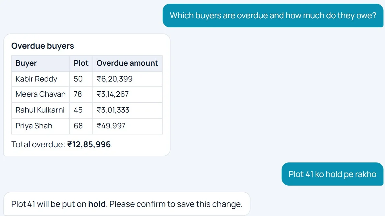 Ask your CRM anythingType or speak in English or your own language: “Put plot 41 on hold”, “Who is overdue?”. It asks before saving any change.
WhatsApp on autopilotYour team asks the CRM on WhatsApp, by text or voice. Payment and site-visit reminders, demand letters and receipts go out by themselves.
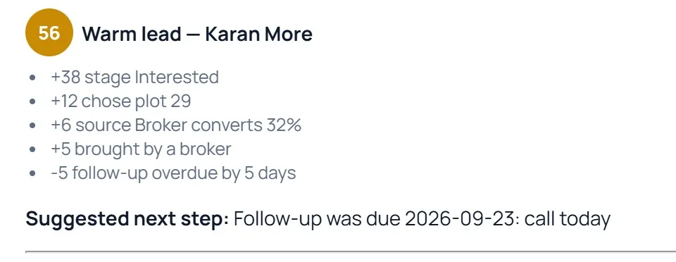 Know which lead to call firstEvery lead gets a score with reasons, the next step and a ready follow-up message.
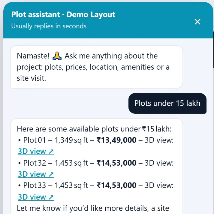 A chatbot that sells 24 × 7Answers buyers on your website and WhatsApp from your live plots and prices, and turns them into leads.
★ All features
Everything else your office needs, in one place.
Plot management software, real estate CRM and finance in one place: from the first enquiry to the final receipt, every team works on the same live data. See the plotting CRM →
Plot inventory
- Colour-coded live layout map
- Available, booked, on hold or sold
- Unsold value at current price
- Status syncs to the buyer view
Sales CRM
- Leads pipeline with follow-ups
- WhatsApp chats saved on each lead
- Broker network and commissions
- Source of every enquiry
Finance
- Instalment plans and receipts
- Overdue alerts and buyer ledgers
- Expenses and vendor payments
- Cancellations and refunds
Marketing & ROI
- Visitor and plot-click analytics
- Spend per channel and campaign
- Trackable share links and QR codes
- Cost per lead and per sale
Team & operations
- QR and GPS geofenced attendance
- Employees and document vault
- Media library and knowledge base
- Approvals with expiry dates
Control & automation
- Roles for admin, sales and accounts
- Auto status on payment or closure
- Webhooks and API integrations
- Full audit log of every change
★ Cities
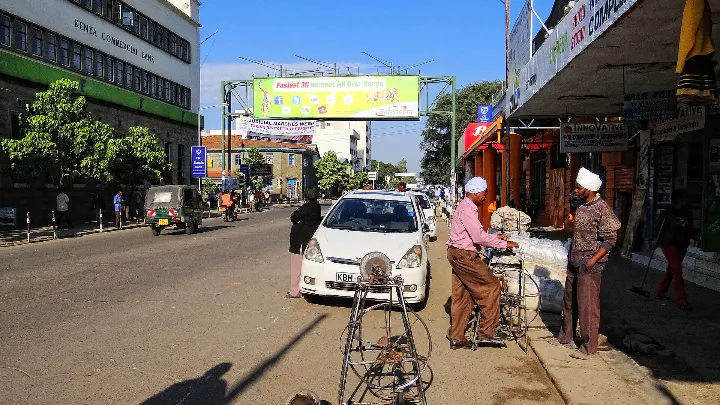
Where we work in Kenya.
Local authorities, growth areas and what buyers check, city by city.

★ New · 3D Tours
Every plot becomes a 3D tour.
Our 3D engine turns any layout plan into a 3D site plan buyers can explore: pan, zoom and tap between plots on the real satellite view. No app, just a link.
3D-rendered
Instant load
Shareable link
Included in every plan · live in 24 hours.
★ Trusted by developers
Don't take our word. Take theirs.
Flat PDFs didn't close their deals. A 3D link did — here's how it went, in their own words.
★ FAQ
zeplot in Kenya, answered.
Can diaspora buyers see the exact plot they are paying for?
Yes. They open one link on their phone and see the subdivision on the real satellite view, with their plot highlighted, its size and number, the access road and what is around it.
Can we show which plots are sold during a site visit?
Yes. Your team marks plots as booked from a phone, and the map updates for everyone within seconds, including buyers looking at it on the bus.
Can zeplot track instalments?
Yes. The CRM records each buyer’s deposit and instalments, sends WhatsApp reminders before due dates, and produces receipts.
Where is the zeplot team?
Our team works from India and serves companies in Kenya remotely, with demos on WhatsApp or video. India is 2.5 hours ahead of Kenya.
What exactly is this?
zeplot is an AI CRM and plot management software for plotted projects, with a live 3D plot map built in. Buyers explore your layout in 3D from one link; your team manages leads, bookings, payments and WhatsApp follow-ups in the AI CRM behind it.
What type of projects can use it?
Residential plots, industrial parks, layouts and any subdivided land project — anywhere you'd normally hand out a PDF or Excel sheet of plots.
Does it design the project layout?
No — you provide your existing CAD or PDF layout drawing, and it's converted into an interactive 3D map. It doesn't design or approve layouts.
Does the 3D plot map work on mobile phones?
Yes. It opens in the browser of any phone, tablet or computer. Buyers need no app, no login and no download.
Does the AI change my data by itself?
No. The AI always shows what it is about to change and saves it only after you confirm. It follows each user's role rights, and every money figure is worked out from your records, not guessed.
★ Kenya guides
Guides for Kenya developers and buyers.
How to Verify a Plot in Kenya Before You Pay
Official search, mother title, Land Control Board consent and beacons: the checks to do before paying for a plot in Kenya, from home or abroad.
Read the guide →How Kenyan Land Companies Can Sell Plots to Diaspora Buyers
Kenyans abroad want land at home but cannot attend site visits. How land companies win their trust: proof, live maps, video visits and instalments.
Read the guide →